Hasankeyf
- Tür: Antik Kent, Kent
- Kültür: Artuklu, Bizans, Osmanlı, Roma, Süryani
- Bölge: Türkiye, Güneydoğu Anadolu Bölgesi, Batman, Hasankeyf
- Durum: Su Altında
Hasankeyf | |
|---|---|
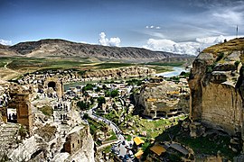
 View of the town from Hasankeyf Castle in 2010
37°42′53″N 41°24′47″E / 37.71472°N 41.41306°E | |
| Country | Turkey |
| Province | Batman |
| District | Hasankeyf |
| Established | 18th century BC? |
| Government | |
| • Mayor | Abdülvahap Küsen (AKP) |
| Population (2021)[1] | 4,329 |
| Time zone | UTC+3 (TRT) |
Hasankeyf[a] is a town located along the Tigris, in the Hasankeyf District, Batman Province, Turkey. It was declared a natural conservation area by Turkey in 1981.[4]
Despite local and international objections, the city and its archaeological sites have been flooded as part of the Ilısu Dam project. By 1 April 2020, water levels reached an elevation of 498.2m, covering the whole town.[5]
The town had a population of 4,329 in 2021.[1]
- ^ a b "31 ARALIK 2021 TARİHLİ ADRESE DAYALI NÜFUS KAYIT SİSTEMİ (ADNKS) SONUÇLARI" (XLS). TÜİK (in Turkish). Retrieved 16 December 2022.
- ^ Avcıkıran, Adem (2009). Kürtçe Anamnez Anamneza bi Kurmancî (in Turkish and Kurdish). p. 56.
- ^ Thomas A. Carlson et al., "Ḥesno d-Kifo — ܚܣܢܐ ܕܟܐܦܐ " in The Syriac Gazetteer last modified June 30, 2014, http://syriaca.org/place/92.
- ^ "Hasankeyf", Ministry of Culture 2005.
- ^ "Water volume in Ilısu Dam 5 billion cubic metre". Haberturk. 1 April 2020. Retrieved 1 April 2020.
Cite error: There are <ref group=lower-alpha> tags or {{efn}} templates on this page, but the references will not show without a {{reflist|group=lower-alpha}} template or {{notelist}} template (see the help page).
✶ Medya


