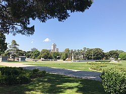
İzmir Kültürpark
- Kültür: Cumhuriyet
- Yüzyıl: 20. yy
- Bölge: Türkiye, Ege Bölgesi, İzmir, Konak, Mimar Sinan (Konak)
Bkz. Mimarlar Odası İzmir İzmir Şubesi – Kültürpark Yapı Envanteri
| Kültürpark | |
|---|---|
 A view of Kültürpark | |
 | |
| Type | Urban park |
| Location | İzmir, Turkey |
| Coordinates | 38°25′40″N 27°08′41″E / 38.42778°N 27.14472°E |
| Area | 420,000 m2 (4,500,000 sq ft) |
| Opened | September 1, 1936 |
| Founder | Behçet Uz |
| Operated by | İzmir Metropolitan Municipality |
| Status | Open all year |
| Parking | 594 parking lots |
| Public transit access | |
| Website | www |
Kültürpark is an urban park in İzmir, Turkey. It is located in the district of Konak, roughly bounded by Dr. Mustafa Enver Bey Avenue on the north, 1395th Street, 1396th Street and Bozkurt Avenue on the east, Mürsel Paşa Boulevard on the south, and Dr. Refik Saydam and Şair Eşref boulevards on the west.
Kültürpark was founded in 1936 on an area of 360,000 m2 (3,900,000 sq ft), which was ruined by the great fire of Smyrna. Since then, it has been hosting the İzmir International Fair. In 1939, the park has expanded to 420,000 m2 (4,500,000 sq ft).
✶ İlgili Yerler
- İzmir Fuarı Paraşüt Kulesi
- İzmir Fuarı Saat Kulesi
- İzmir Tarih ve Sanat Müzesi
- Eski Evkaf Pavyonu
- Emekçi Atlar Heykeli
- Atatürk ve İsmet İnönü Heykeli, Kültürpark
- Yatan Kadın Heykeli 1, Kültürpark
- Yatan Kadın Heykeli 2, Kültürpark
- İzmir Tarihi Liman Kenti
- 9 Eylül Kapısı, Kültürpark
- Montrö Kapısı, Kültürpark
- Lozan Kapısı, Kültürpark
- 26 Ağustos Kapısı, Kültürpark
- Cumhuriyet Kapısı, Kültürpark
- Eski Maarif Vekaleti Kültür Pavyonu
- İzmir Resim Heykel Müzesi Kültürpark Sanat Galerisi
- Kültürpark Ada Gazinosu
- Kültürpark Göl Gazinosu
- Kaskatlı Havuz
- Uzun Havuz, Kültürpark
- Behçet Uz Heykeli
- Nazım Hikmet Heykeli, Kültürpark
- Kültürpark Çeşmesi