Zeytun
- Tür: Kent
- Kültür: Ermeni
- Bölge: Türkiye, Akdeniz Bölgesi, Kahramanmaraş, Onikişubat
You can help expand this article with text translated from the corresponding article in French. Click [show] for important translation instructions.
|
Süleymanlı
Zeytun / Զէյթուն | |
|---|---|
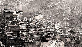
 Zeytun in 1915 | |
| Coordinates: 37°52′34″N 36°49′59″E / 37.87611°N 36.83306°E | |
| Country | Turkey |
| Province | Kahramanmaraş |
| District | Onikişubat |
| Population (2022) | 475 |
| Time zone | UTC+3 (TRT) |
Süleymanlı, historically Zeitun (Armenian: Զէյթուն), Zeytun,[1] Zeytunfimis or Zeytünfimis, is a neighbourhood of the municipality and district of Onikişubat, Kahramanmaraş Province, Turkey.[2] Its population is 475 (2022).[3]
The village has an ancient history as a center of settlement. It was established on the Zeytun Stream in a narrow valley between the Ceyhan River and the Göksun Stream in the west of Maraş, between the high mountains and 69 km (43 mi) north of the center of Kahramanmaraş. The surface of the region has a very indented and protruding surface as it is cut by many streams with abundant water and strong flow. For this reason, the houses have an irregular appearance of leaning on steep slopes.
✶ Medya

