The third tier of walls surrounding the city—which the people of Ankara at that time called “Yoğun Duğar”—was built in 1606–1607 by the people of Ankara, who drew upon the Ahilik tradition during the Celali Rebellions that swept across all of Anatolia, under the leadership of Qadi Vildanzâde Mevlâna Ahmed Efendi. Ergenç has written that construction of this wall must have begun between 1604 and 1606. According to the Ankara Shari’iyya Registers, during the time of Çelebi Mehmed Efendi, the Qadi of Ankara prior to Vildanzâde, (1601–4), ditches were dug around the city for its protection; and since there was definitely no wall surrounding the city during that period, Turan’s claim that construction of this wall began during the Seljuk period is unfounded. Despite this precaution, after Celalî Karakaş Ahmet raided the city and set fire to the Samanpazarı and Hamamönü neighborhoods, a decree dated February 26, 1607, found in the Ankara Shari’a Registers states that the Ankara Qadi reported that “because the people had built the wall with their own funds out of fear of bandits,” and that they were already unable to pay their taxes for the years 1605–1606 and had been reduced to destitution by the new taxes imposed. Under these circumstances, it is also unfounded to claim that the wall was constructed by Cenabî Ahmed Pasha, who was the Anatolian Beylerbey in Ankara at that time.
Baron Ghislen de Busbecq, the ambassador sent by Emperor Franz Ferdinand of Austria-Hungary to Sultan Suleiman the Magnificent, arrived in Ankara, noted in his travelogue that “there was no city wall around the lower city” and did not include it in the sketch of Ankara he drew.
Turan states that, according to information provided by a Polish envoy who visited Ankara in 1608, “the wall had now been completed.” Simeon, a Pole who arrived in Ankara in 1618 or 1619, wrote that Ankara was “a commercial city surrounded by three tiers of walls: outer, middle, and inner.”
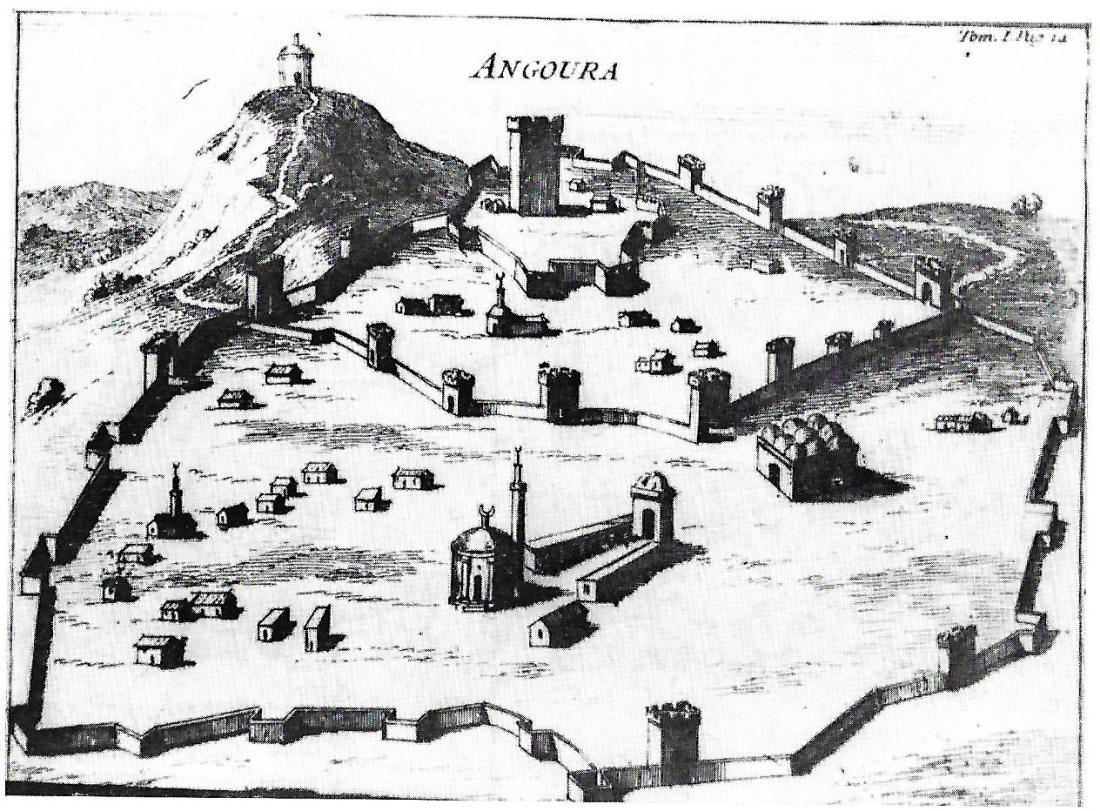
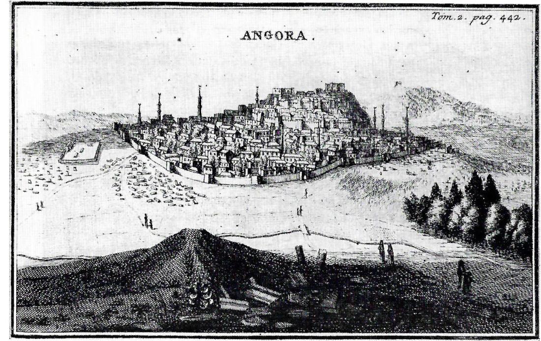
French travelers Piton de Tournefort in 1701 and Paul Lucas in 1705 depicted this outer wall very clearly in the engravings they created to describe the state of Ankara at that time. Lucas noted that seven of these gates were large and beautiful, but the others were no larger than a passageway through which a single person could pass.
Evliya Çelebi, who arrived in Ankara in 1648, made no mention of the walls—likely because he had only seen them—but noted that the city had four gates.
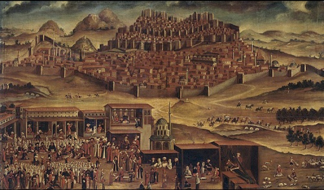
In the early 18th-century painting “View of Ankara,” believed to be by the Dutch artist Vanmour, a third wall surrounding the city—which extends beyond the castle’s two-tiered walls— the square bastions lined along this wall, and the roads extending from some of these bastions and connecting Ankara to other cities are clearly visible.
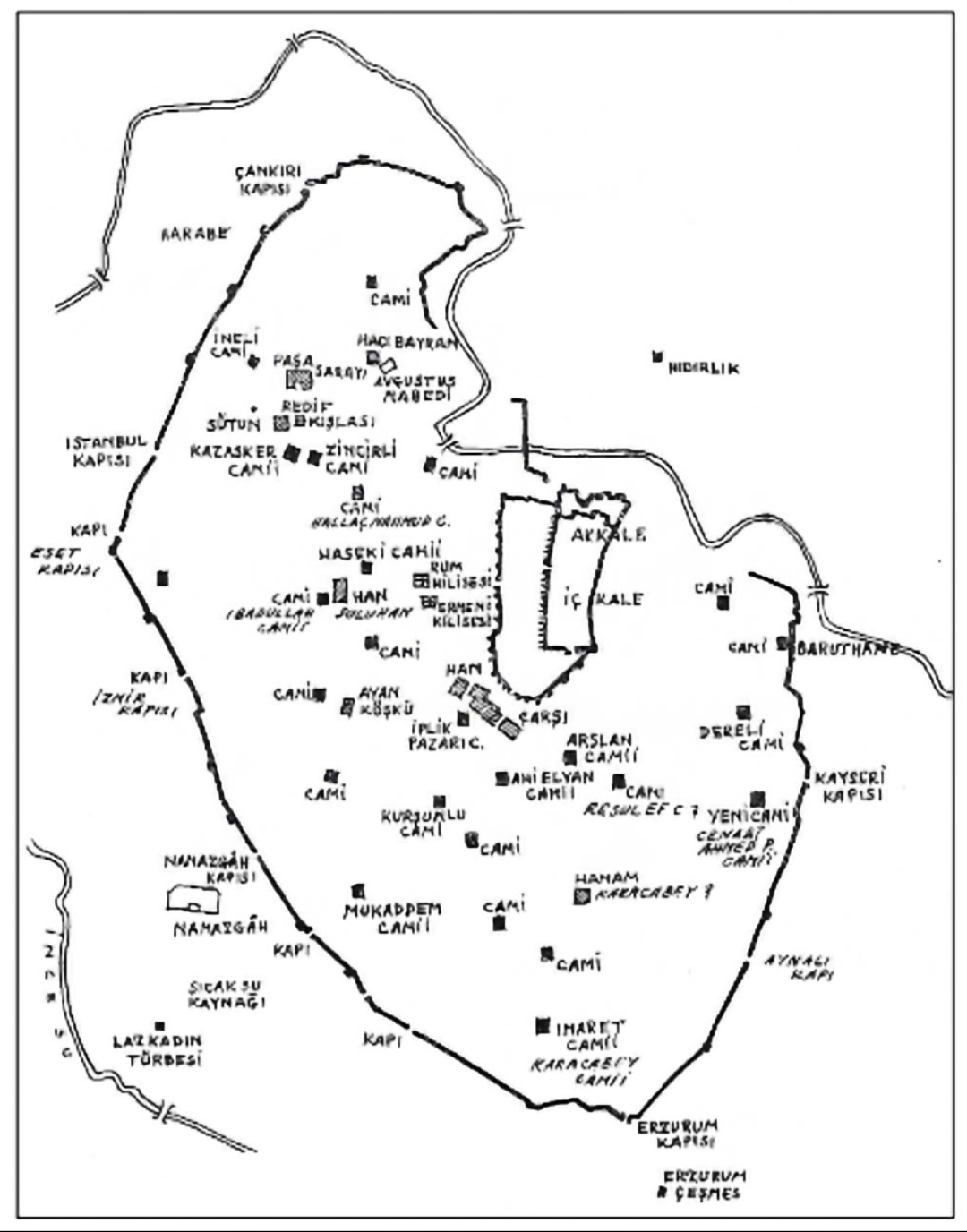
The 17th-century Ottoman Wall, of which not even the slightest trace remains today, can be seen in full detail in the Map of Ankara drawn in 1838 by Prussian Captain Baron Fischer von Vicke, who served as an advisor to the Ottoman army.
Starting in 1860, the city began to expand beyond these walls, and as a result of urban development tied to the city’s growth, this outer wall gradually disappeared by the early years of the Republic. When German archaeologists C. Humann and O. Puchstein arrived in the summer of 1882 to examine the Temple of Augustus, they noted that the outer wall was being demolished piece by piece and that the resulting land and stones were being used in construction projects.
The wall, along with its gates and the routes it followed, was described in the greatest detail by Ernest Mamboury, in the section titled “The Ottoman Wall in the Plain” of his book *Ankara Guide Touristique*, published in 1934, without going into detail, and included a photograph of the remaining section of this wall at Çankırıkapı.
Prof. Dr. Semavi Eyice, in his article “An Old Painting of Ankara,” in which he discusses the painting “View of Ankara” believed to be by the Dutch painter Vanmour,’s Old Painting,” in which he discusses the painting “View of Ankara” attributed to the Dutch painter Vanmour, he also mentions the outer wall encircling the city and, by identifying the towers visible in the painting, describes the roads leading from them.
On the Vincke Plan, it can be seen that after the Çankırı Gate, the wall continues past the ruins of the Roman Baths, passing through the city. From this gate, it runs along the western side of what is now Çankırı Street, reaching the Bahçeler Gate at the beginning of Soğukkuyu Street. From there, it proceeds to the Istanbul Gate, located northwest of the Old Parliament Building on Ulus Square. It exits through the Eset Gate, situated below the Second Parliament Building, and turns southeast. From there, it passes in front of the Vakıflar Building—which houses the General Directorate of State Theaters—and proceeds along İstiklâl Street to reach the İzmir Gate at the beginning of Adnan Saygun Street in Hergele (now Opera) Square.
The wall follows the eastern edge of the square, passing behind the Ottoman (Melike Hatun) Mosque—which opened in 2018—and then, again along the edge of the square, past the front of the Yenice Mosque, toward the Namazgâh Gate at the intersection of Denizciler Street and Talat Paşa Boulevard. On the 1924 map, there are no settlements beyond the Yenice Mosque; instead, cemeteries begin a short distance further on, likely outside the city walls.
Since the 1924 map shows no urban settlement in this area beyond the Namazgâh Gate, the wall may have run east of the Nümune Hospital, in line with the direction of travel. On the Vincke Plan, the wall then runs along the edge of the İncesu Creek plain—which is nestled between two small hills—in accordance with the topography. Today, this point is likely located on the plain between Ankara Medical Faculty and Hacettepe Children’s Hospital, at the start of the Adnan Saygun Street slope, slightly below where Gevher Nesibe Street—which presumably runs through the grounds of Hacettepe Hospital—begins.
From there, it leads to a small gate located on the internal road next to Hacettepe Children’s Hospital, near Gevher Nesibe Street. The cemetery southwest of Karacabey, which appears on both the Vincke Plan and the 1924 map, is situated on a hill according to the topographic features shown on the Vincke Plan; therefore, today, on Hacet Hill—which has been converted into an open parking lot south of Gevher Nesibe Street, which runs through the center of the Hacettepe Hospital campus. Konyalı writes that this cemetery was located around the Karacabey Mosque. The city wall passes through the summit of the hill in the center of the cemetery and turns eastward at the edge of the cemetery, leading to the Erzurum Gate. On the Vincke Plan, the Erzurum Gate is shown to be located considerably below the current intersection of Sarıkadın and Erzurum Streets. Based on this, the Erzurum Gate today may be located further south of where Sarıkadın and Erzurum Streets open onto Dumlupınar Avenue—perhaps somewhere near the beginning of Geçim Street.
From there, the wall runs north-northeast, reaching Aynalı Gate at the intersection of Talat Paşa Boulevard—which comes from in front of the Karacabey Bathhouse—and Dumlupınar Avenue. After this gate, the wall continues northward, likely along what is now Kestane Street, passing the Ulucanlar Ankara Training and Research Hospital—the eastern block of which is located across from the Yeni Mosque (Cenabî Ahmet Paşa Mosque) in Ulucanlar—at the Ulucanlar Intersection, and then northward to the Kayseri Gate, located near the Ulucanlar Social Security Center between Gazeteci Kemal Aşık Street—which merges with Bentderesi Street—and Şafak Street to its east.
In the Vincke Plan, the wall, which turns slightly northwest in a gentle curve from Kayseri Gate, reaches a small gate at the northeastern corner of the Direkli Mosque (shown on the plan as the Dereli Mosque), at the start of the flat area formed by a small stream that flows into the Hatip Creek. This small stream appears to have flowed between a small hill—on which the Ulucanlar Prison, now a museum, stands along the eastern edge of Şafak Street—and another small hill at the foot of the Direkli and Kayabaşı mosques to the west. Today, Gazeteci Kemal Aşık Street likely follows the same route across this former stream plain.
On the Vincke Plan, the Ottoman Wall, after passing through this small gate near the Direkli Mosque, runs along the base of the settlement without descending into the stream’s plain, passes just east of the Kayabaşı Mosque, and turns west. The route it followed corresponds to the western edge of Gazeteci Kemal Aşık Street today. On the 1924 map, there is a gap between the Kayabaşı Mosque and the Şükriye Neighborhood to its east, and there is no settlement north of the line connecting the northern edge of the neighborhood near the Kayabaşı Mosque with the Molla Büyük Mosque. This settlement line may indicate the path taken by the wall. The wall, turning westward, runs north of the rocky slope in front of the Molla Büyük Mosque. The trace of the wall disappears in the steep rocky terrain surrounding the north and west of the mosque, “but it is presumed that the wall connected to the Eastern Fortress (Şark Kalesi), the highest tower of the castle in the southeast.”
On the Vincke Plan, starting from the last bastion of the castle walls located on the southern edge of Hatip Creek (today’s Bentderesi Street)—at the beginning of what is now the Kaledibi Parking Lot—and then crossing over the now-nonexistent Roman Aqueduct to the small hill to the left of Hıdırlık Hill across the way (west of the Atıfbey Neighborhood, which is now situated on Hıdırlık Hill) and then turns due west, ending at the rocky outcrop opposite the Tabakhane Mosque. It resumes below the rocky outcrop, passing by the Ördekler Bridge—located immediately southeast of the Şeyh İzzeddin Mosque in that era (today, likely at the entrance to Kevgirli Street from Bent Deresi Avenue)—and from there crosses to the (today the street) to the west bank of the stream. Mamboury also writes that the Ottoman Wall, circling the foot of Hıdırlık and crossing to this side opposite the Ördekler Bridge.
From there, the Ottoman Wall follows the city-side bank of the Hatip Creek to the narrow passage at the end of Ulucak Street. Mamboury writes that at this point, the wall “reaches two small towers that allow passage along Ulucak Road.” This road is also visible on the 1924 Map; today it is known as Ulucak Street and is likely a dead-end road ending near this small gate. After the tower at the passage, the road turns northwest and, upon reaching the summit of the hill north of the Osmaniye Mosque and neighborhood, this section likely marks the endpoint between the two ends of today’s Tepe Street; following the slope of the hill westward, it reaches the Çankırı Gate at the beginning of Çankırıkapı Street, across from the YIBA Market.